Saved Anchal office trip
Got the exact polygon for my plot in Saran. The Landeed report had Bhunaksha + Jamabandi side by side — saved me a trip to the Anchal office.
Manish K.2 months ago
Got the exact polygon for my plot in Saran. The Landeed report had Bhunaksha + Jamabandi side by side — saved me a trip to the Anchal office.
My neighbour and I were disputing 5 Kathas. The cadastral map showed the boundary clearly. Done.
Used for plot verification before sale registration in Patna. Both soft and hard copies on time.
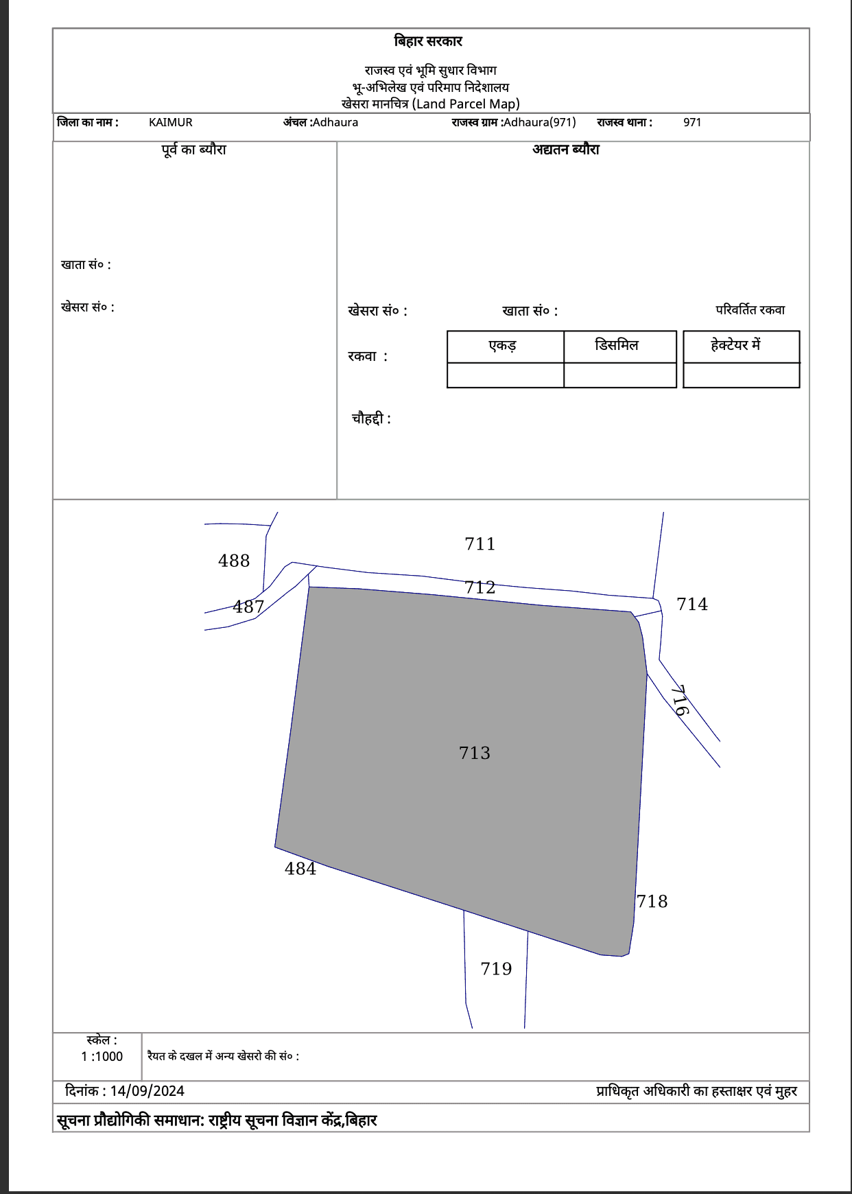
Bihar Bhunaksha is the digital cadastral map of rural land in Bihar, showing each plot's polygon, area, Khata, and neighbouring plots. It is maintained by the Department of Revenue & Land Reforms and complements the textual Jamabandi maintained on Parimarjan.
District, Sub-Division, Circle (Anchal), and Mauza are mandatory. Within the Mauza, you can search by Sheet number + Plot number (Khasra), or by Khata number in select Anchals.
The plot polygon, plot/Khasra number with sub-division, area in Decimal/Katha/Dhur, Khata number, classification (Raiyati / Aam / Sarkari), neighbouring plots, and the survey reference (Cadastral, Revisional, or Special Survey).
Mauza is Bihar's revenue village — the basic unit for land records. Every plot is identified by its Mauza first, then the Sheet number, then the Plot/Khasra number. A Tehsil/Anchal contains many Mauzas.
Bhunaksha is the map of the plot — boundary polygon and area. Parimarjan Jamabandi is the text — owner name, ownership share, Khata, and rent (lagaan). The two are linked through the Khata number; for any rural transaction you typically check both.
Colours indicate the land's classification — Raiyati (private holding), Aam (community/grazing/road), Sarkari (government / forest / public utility). Each Anchal's legend is shown on the map view; classification affects whether and how the plot can be sold or built upon.
Decimal (most common), Katha, and Dhur. 1 Katha varies by region — Magahi Katha ≈ 1361 sq ft (Magadh region); Mithila Katha differs. 1 Bigha = 20 Katha. Modern records also show hectares.
The online copy is an informational copy, accepted for KYC, KCC loans, scheme verification, and pre-purchase due diligence. A certified copy with revenue stamp from the Circle Officer is needed for sale-deed registration, bank mortgage, or court submission.
Parimarjan is Bihar's online portal for textual Jamabandi (Record of Rights). It maintains the Khatian, owner details, and mutation history. Bhunaksha (map) and Parimarjan (text) are used together for complete due diligence.
Older Cadastral (1908–14) survey records used manual chains; modern Revisional and Special Surveys use GPS and aerial imagery. Discrepancies are common in older Mauzas where re-survey hasn't been completed. In such cases, apply for a Tippan / Amin verification at the Anchal office.